Travel-Maine.Info
|
Main Menu
Home
Blog
FALL
Fall Foliage
Apple Orchards
Halloween
Hunting
Thanksgiving
WINTER
Alpine Skiing
Nordic Skiing
Snowmobiling
Ice Fishing
Dogsledding
Snowshoeing
SPRING
Maple Syrup
SUMMER
Biking
Birding
Seacoast
Whitewater Rafting
Kayaking
Camping
Hiking
Fishing
Summer Camps
Windjammers
THINGS TO DO
Vacation Planner
Shopping
Places to Visit
Recreation
Forts
Lighthouses
Museums
HELPFUL PAGES
Cities & Towns
Maine Blogs
Maps
Maine News Media
Books about Maine
Business Directory
Business Services
Real Estate
Fort O'Brien
Machiasport, Maine
Home > Places to Visit > Historic Forts > Fort O'Brien
Fort O'Brien is located in Machiasport, Maine overlooks the Machias Bay. It is adjacent to the Fort O'Brien School and has
nice greens for picnics and a wonderful view of Machias Bay. The fort was active during the Revolutionary War, the War of 1812, and the Civil War.
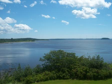
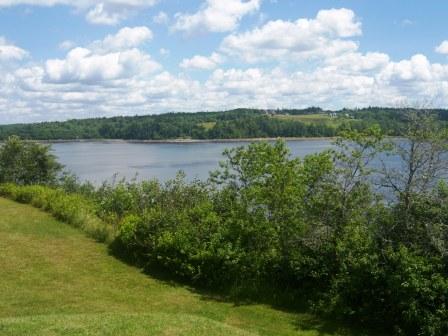
View from Fort O'Brien - looking east across Machias Bay
Revolutionary War. The fort was first built in 1775 and consisted of small breastworks to guard the mouth of the Machias River. The first naval engagement of the Revolutionary War was fought just offshore the fort five days before the Battle of Bunker Hill. The British would later destroy the fort in the same year when it sent four ships into the Machias Bay. The fort was rebuilt again in 1777 and was named Fort O'Brien in 1781 - in honor of Captain Jeremiah O'Brien - a revolutionary war hero from Machias, Maine.
War of 1812. In 1808-1809 a blockhouse, barracks, and battery were constructed. During this time period there was a four-gun crescent-shaped earthwork established. In 1814 the British captured the fort and destroyed the barracks.
Civil War. In 1863, some earthworks were put in and a battery of five guns emplaced adjacent to the ruins of Fort O'Brien. However, this fort saw no action during the Civil War. The fort was called Fort Machias during the Civil War.
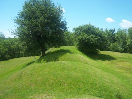
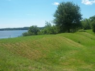
Earthworks of Fort O'Brien - facing south
Directions and Maps to Fort O'Brien
From East Machias - take Port Road into Machiasport.
From Machias - take Route 92 south.
Regional Map of Machias Bay Area. Chamber of Commerce.
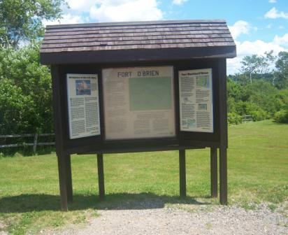
An information kiosk is located on the fort grounds.
Other Web Sites with Information about Fort O'Brien
Maine Department of Conservation. Web page by the state of Maine provides information on the fort and the cannons that were emplaced. Much more history is provided as well.
Portland Public Schools. The web page provides info about the civil war era of Fort O'Brien.
Fort Tour Systems, Inc. Provides info and a photo about Fort O'Brien.
Maine Historic Sites. Fort O'Brien.
Historical Notes of Machias and the War of 1812. USGW Archives.
View from Fort O'Brien - looking northeast across Machias Bay
News Articles, Documents, and Publications about
Fort O'Brien in Machiasport, Maine
May 22, 2010. "Margaretta Day to mark naval battle". Bangor Daily News.
September 25, 2000. "The Forts of Maine". By Frederick W. Chesson.
Home > Places to Visit > Historic Forts > Fort O'Brien
|
|
AdsThe website is an Amazon Associate and earns money for qualifying purchases.
|
|
|